
Editing points, one or a thousand
Change a description, an elevation or how a point looks, for one point or every point you have selected.
4 min read
Selecting the points
- Click a point on the map in Points mode.
- Shift+click to add more.
- Drag a box to take everything inside it.
- Or select in the points table, which stays in step with the map.
Changing them
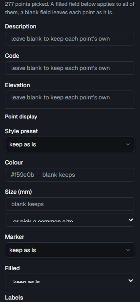
The editor beside the map applies to everything selected. Change one field and it lands on all of them; leave a field alone and it is not touched.
- Description, for a whole class of shots at once.
- Elevation, including a decimal, typed as you would say it.
- Display: style preset, colour, marker, size, and every label setting.
Draw and Survey are the same points
A point placed in Draw shows up in Survey, and a point styled in Survey draws that way in Draw. There is one pipeline, so the map and the plan cannot disagree.
Point display settings
| Setting | What it does |
|---|---|
| Style preset | A named symbol from the catalogue or your own |
| Colour | Overrides the style's colour for these points |
| Size (mm) | The marker's size on the printed sheet |
| Marker | The symbol itself, cross, circle, triangle, and so on |
| Label height (mm) | Text size on the sheet |
| Label gap (mm) | How far the label sits off the marker |
| Label angle (°) | Rotation, counter-clockwise as a surveyor reads it |
| Label layout | Which attributes show, stacked or side by side |
| Number / elevation / description | Which of the three are labelled at all |
A selected point still shows its own symbol
The selection ring is drawn around the marker, never over it, so restyling something you have selected shows immediately.
From the drawing, without leaving it
Imported points are drawn on the Draw canvas too, exactly the way their display says, style, marker, size and labels. Click one there and the same editor opens in the properties panel: number, description, code, height and display. Shift+click adds another point, so a handful can be resized or described in one go.
- Size has a list of the sizes plans are drawn at, and the field still takes any value.
- Plan coordinates are read-only wherever a point is edited, the database protects them.
- A point drawn on a drawing is still a point of the project, not an entity of that drawing: object snap catches it, and it is never saved into the drawing or exported as part of it.
Read next
- Point styles and labelsChoose a symbol, size it in millimetres, and arrange the labels the way your office wants them.
- Description keys: symbols from field codesA shot coded 460 draws as a hydrant before anybody opens a picker. Here is how that works and how to override it.
- Importing survey pointsGet a points file in, map the columns, and know exactly what was accepted.
Something here wrong or missing? Tell us and we will fix it.